


açıklaması Surveyor
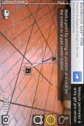
With Surveyor, you can measure distances by placing markers on a virtual ground that is overlaid on the camera image.
Surveyor locks the virtual ground to the real world so no matter which direction you turn to, the markers will always stay where it is originally placed.
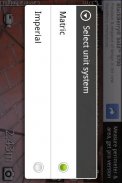
Distances between each markers are calculated and displayed on the screen in the unit system you specified. With the pro version you can place more than 2 markers and even get the area of the space surrounded by the markers.
</div> <div jsname="WJz9Hc" style="display:none">Surveyor ile, kamera resmi üzerine bindirilmiş bir sanal zemin üzerinde işaretler koyarak mesafeleri ölçebilirsiniz.
Özgün yerleştirildiği, işaretleri her zaman kalacak size çevirmek yönde olursa olsun öylesine Ölçücü gerçek dünya için sanal yere kilitler.
Her işaretleri arasındaki mesafeler hesaplanmış ve belirlenen birim sisteminde ekranda görüntülenir. Pro sürümü ile fazla 2 işaretleri yerleştirmek ve hatta işaretleri çevrili kalan alan alabilirsiniz.</div> <div class="show-more-end">
Surveyor - Sürüm 2.5.2
(14-02-2013)Surveyor - APK Bilgisi
APK sürümü: 2.5.2Paket: com.miian.android.surveyorAynı kategorideki uygulamalar
Hoşuna gidebilecekler...


